|
|
G |
| I | S |
A collection of Open-Source Mapping tools.
My goal is to provide free, powerful web applications to help make Mapping easy and accessible.
To do this, I am learning how to make an Open-Source project sustainable and figure out a way to get paid for my time working on it. This is an overview of my progress so far.
Jump to a project:
What is Open-Source Software?
Open-Source software is software that anyone can view, use, and modify. Including for commercial purposes.
Instead of being controlled by one company, the code is shared publicly so that individuals, communities, and organizations can collaborate, improve it, or build on it. This open approach is the foundation of much of the modern Internet and software as a whole.
Many of the tools and technologies behind the websites, apps, and services we use every day are built on Open-Source software. For example, the Android operating system, the Firefox and Chrome browsers, and even the basic building blocks of websites (like HTML, CSS, and JavaScript) rely heavily on Open-Source contributions.
Without Open-Source software, the web as we know it wouldn’t exist.
Open-Source software is not just about free software; it’s about freedom of choice, collaboration, and innovation. It allows anyone to contribute, learn, and benefit from the collective knowledge and creativity of the global community.
About Joe
 Thanks to Open-Source software, I have been building things for the
web both for fun and professionally since 1997. I run an eBay
advertising service called
Auction Nudge and
contribute to the Open-Source software. Currently the former pays
for the later.
Thanks to Open-Source software, I have been building things for the
web both for fun and professionally since 1997. I run an eBay
advertising service called
Auction Nudge and
contribute to the Open-Source software. Currently the former pays
for the later.
Open-Source technologies have empowered me (and many others) to create and run my own business with almost no startup costs. Using the generosity of others to create value for others and a living for myself. This is a very powerful concept.
In my spare time I enjoy outdoor activities (especially cycling) and my love of the outdoors is what started my journey into GIS.
The Master Plan
Getting paid to work "for free".
Being creative, tackling interesting problems and building things that add value for others.
So far, while I have a growing userbase and positive feedback, the project is far from financially sustainable. While I believe in the value of Open-Source, the project can only continue if I can figure out an income stream.
By following my interests in this field, and by learning through doing, I have developed a broad understanding of GIS technologies on the web. By doing this in the open, my software products are gathering a small, but loyal userbase.
Progress
Learn by doing...
ogis.app
Rich web-based map editor built with Waymark JS.
The Open GIS App is a full-featured web-based Map Editor that uses Waymark JS to create and edit Maps. It runs in the browser and allows users to create and share Maps without needing to install any software.
Designed for both desktop and mobile devices, your edits are saved in the browser's local storage, so sessions persist even if you close the tab or browser. You can also export your Maps to save them offline or share them with others.
Waymark JS
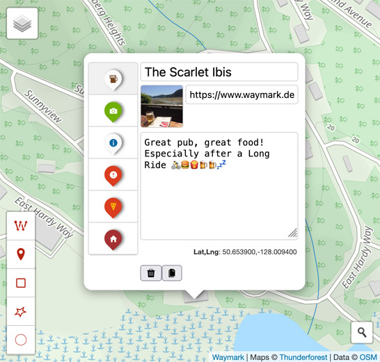
A JavaScript library for creating and editing Maps.
It includes a Map Editor, Viewer and controls for how Overlays appear.
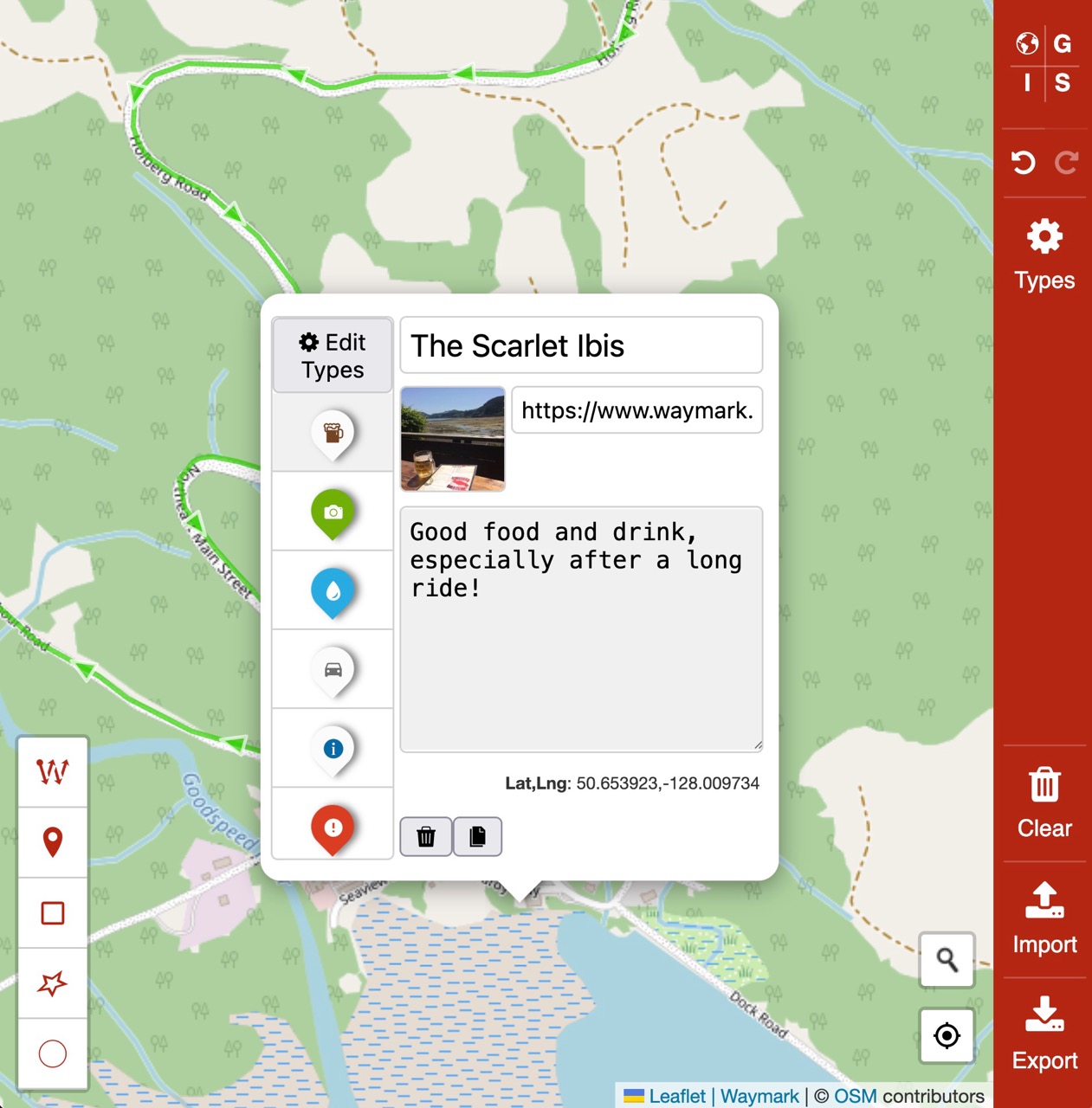
The Editor
The Editor runs in your web browser and allows you to:
- Import data from various formats (GPX, KML and GeoJSON)
- Create Overlays (Markers, Line & Shapes) using the intuitive interface
- Add meaning to your Maps by styling Overlays using Types
- Export your Maps to save them offline, including your custom Types.
No account or API key is required to use the Editor and Maps are stored in your browser's local storage.
Map First
A minimal Wordpress theme with an obsession for maps.
Designed for use with Waymark, Map First is a minimal WordPress theme that demonstrates many of Waymark's features. View the source code to see comments that explain how the theme works, or use it to start building a custom Geographical Information System (GIS) powered by WordPress.
inReach MapShare
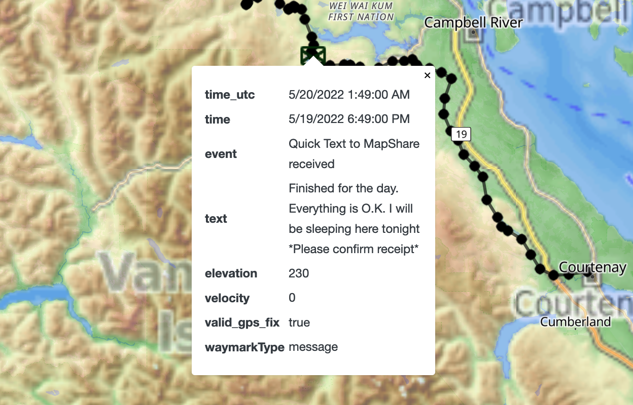
A better wasy to share your Garmin inReach location on the web.
A WordPress plugin to display your live Garmin inReach data. These satellite communication devices are used for outdoor activities, especially in remote areas where cellular coverage is not available.
The plugin allows the user to embed a Map on their website, showing the current location and route of their inReach device. The Map is responsive, so it works on both desktop and mobile devices and has a number of customisation options.
The plugin enables WordPress users to automatically share their location with friends and family from anywhere in the world. While Garmin has their own tools for this, this plugin makes the process much simpler.
I use this plugin myself to share my location on bikepacking trips, often in remote areas.
Comox Valley Trails
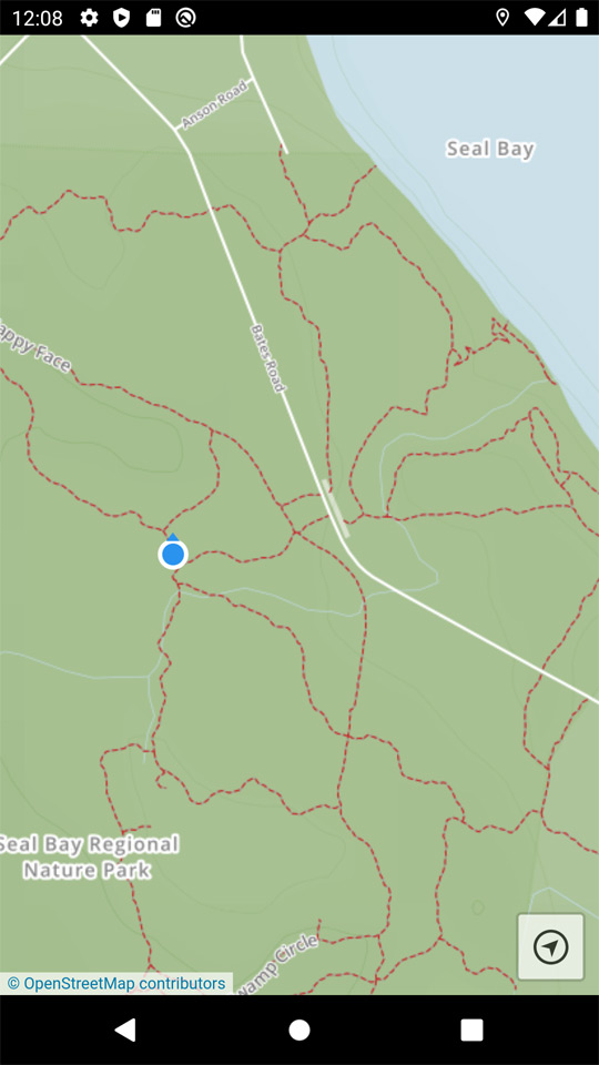
Providing free trail maps based on OpenStreetMap data.
A mobile app providing offline trail Maps of the Comox Valley regions in British Columbia, Canada. Available through the browser or through the Apple and Android app stores for offline use.
The app was dessigned to be simple and only included one button - "locate", which uses your device GPS to display your current location (and which way you are facing). This is especially useful when navigating trails in terrain without cellular service.
This project taught me alot about distributing topographical maps to users using web technologies, as well as the logistics of hosting apps through app stores.
Waymark for WordPress

An Open-Source WordPress plugin to easily create, edit and share meaningful Maps.
My goal with Waymark was to learn how to create and support a popular Open-Source WordPress plugin that makes the experience of creating Maps an intuative and easy on.
WordPress is the most popular Content Management System (CMS) in the world and currently powers over 43% of all websites. It is also Open-Source and has an established community.
Using the popular Leaflet library, the plugin allows users to create and edit Maps with an intuitive interface. Users can add Overlays (Markers, Lines & Shapes) to their Maps and style them using Types. Waymark uses OpenStreetMap as the default Basemap.
The plugin has approximately 1000 users, and all sorts of use-cases (from dog walks to transport maps).
The plugin has been made better by user contributions (feedback/ideas/code/translations) and is currently officially available in the following languages in addition to English:
- Dutch
- Spanish (Spain & Chile)
- Croatian
- German
- Italian
Thanks to the WordPress translation community, Waymark is becoming more accessible to users around the world.
Cumberland Trails
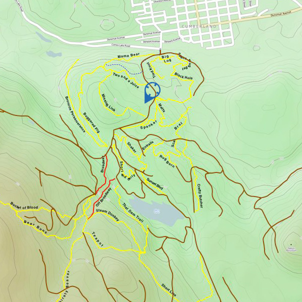
A web-based Map of the trails in the Cumberland region of British Columbia, Canada.
For this project I personally recorded GPS tracks of trails (by running and riding them), overlaying them on top of OpenStreetMap data to create a detailed map of the trails.
I then created a georeferenced map of the area using Photoshop, which combined with the users current loction and heading could be used for navigation.
While the map was never published, the project was a valuable learning experience in creating maps and working with geospatial data.
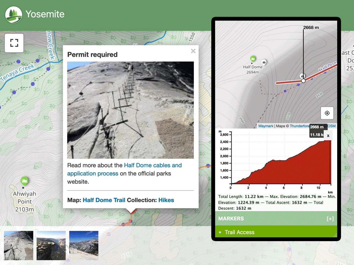
Big Hikes Yosemite
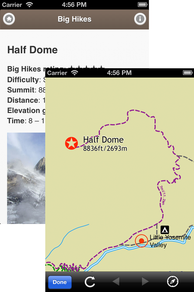
A web-based Map of the Big Hikes in Yosemite National Park.
Big Hikes Yosemite was a free app which contains information about four strenuous day hikes in the Yosemite Valley area of the Yosemite National Park (California, United States).
Containing detailed trail descriptions, original photographs, trail maps and trail head information which I research and created myself. The map itself I created offline using Ortelius (now defunct), combining my own GPX with existing public data.
This was my first forey into both native mobile app development and map creation. I learned a lot about the process of creating and distributing apps through app stores.
Lessons so Far
Running an Open-Source Project
Gathering experience with Github, by running a project in the open.
The next stage is creating a product or service people are willing to pay for.
Slow progress, people are used to getting amazing software for free. Can be hard to even get reviews, let alone sponsors.
The feedback received has been positive and encouraging.